Can Planes Land in Fog?
Can Passenger Planes Land in Fog?
Yes, most commercial aircraft are capable of landing in thick fog, but it can depend on the type of aircraft and the facilities associated with the runway and airport. Some planes can land when the visibility is as low as 75 metres.
For the vast majority of commercial flights, the pilot disconnects the autopilot when on final approach (typically between 1,000 and 500ft) and lands the aircraft manually. For the pilots to manually conduct the landing, the outside visibility must be a minimum of 550 metres and the cloud base must allow the pilots to see the runway when the aircraft is at 200 feet above the ground. If they can’t see the runway at this point, they can’t continue the landing and must fly a ‘go-around’. If the pilots won’t be able to see the ground by 200ft or the visibility is less than 550 metres, the pilots must carry out an ‘autoland’ where the aircraft’s autopilot lands the aircraft automatically.
The observed visibility is referred to as Runway Visual Range (RVR) which is measured by specialist equipment called transmissometers which are located next to the runway. The altitude above the ground at which the pilots must be able to see the runway is termed the ‘decision altitude’. It is at this altitude that the pilots decide whether to continue with the landing or abort it.
What is Autoland on a plane?
If the visibility is less than 550 m and/or the pilots can’t see the runway at a height of 200ft above the airport, it is still possible to land, but the landing would need to be conducted through what is called an ‘autoland’. This is where the autopilot completes the landing automatically with the pilots only taking manual control as the aircraft slows down after it has touched down on the runway.
Most commercial planes can therefore land using the autopilot in thick fog with visibilities as low as 75 m and no decision height (i.e. the pilots don’t have to be able to see the runway until the aircraft has touched down).
Why do Pilots Need to use Autoland?
The reason why an automatic landing is conducted in foggy conditions is down to the need for the aircraft to be flown incredibly accurately down to a very low altitude when the pilots can’t actually see the runway. It is simply much safer to allow the aircraft to ‘fly by numbers’ as it would be extremely challenging for the pilots to match the accuracy of the autopilot in such conditions. The pilots still have the challenging task of vigorously monitoring the aircraft and its systems and stepping in when things don’t go to plan.
An Autoland needs to be planned in advance. You can’t plan to do a manual landing, then get to 200ft, not be able to see the runway and let the Autoland do the landing for you; the aircraft has to be setup properly before-hand and the pilots need time to adequately prepare. Most pilots will tell you that setting the aircraft up for and Autoland, and then monitoring it throughout the approach and landing is far more laborious than landing the aircraft manually.
Aircraft Autoland Capabilities
Having an aeroplane with Autoland capabilities is a bit like choosing to have parking assist on a new car. Autoland is normally an optional extra that the airline can choose to have installed on their aircraft but it comes at a cost. You can therefore be in a situation where the same aircraft types have different specifications, i.e. one B737-800 may have Autoland capabilities, but another one doesn’t.
Various aircraft also have different limitations regarding how low the visibility can be. As mentioned above, if the runway visibility is below 550m, the autopilot must do the landing. Some aircraft can land down to a minimum visibility of 300m whilst others might be 200m, 100m or 75m.
Aircraft are allowed to (and commonly do) fly with certain technical defects where there is suitable redundancy or the system isn’t critical. This can affect the Autoland status of the aircraft and downgrade it to not allow automatic landings until the problem is fixed. You probably wouldn’t want your flight cancelled because the Autoland system is temporarily inoperative but there is no fog forecast for the next week!
Pilot Autoland Capabilities
Unintuitively, pilots have to be trained to a higher standard to allow the autopilot to do the landing rather than doing it themselves. They have to undergo specific training to ensure they are ‘Low Visibility Procedure’ (LVP) qualified. If the pilots have not completed this specific training and been signed off as competent, they are only permitted to manually land the aircraft. This training needs to be completed once a year and consists of conducting a take-off and landing in thick fog as well as dealing with technical malfunctions that require the approach to be aborted at low altitude.
Airport Autoland Capabilities
The airport itself must have certain infrastructure in place to allow aircraft to Autoland. This is in the form of navigation equipment such as an Instrument Landing System (ILS). There are various categories of ILS which allow landing in certain visibilities. Most of the time, a CAT 1 ILS is used which directs the pilots to 200ft above the airport at which point they disconnect the autopilot and manually land. However, in low visibility conditions where the visibility is less than 550m, a higher category of ILS must be installed to allow an Autoland to be completed, for example a CAT 2 or CAT 3 A/B or C.
The category of ILS is determined by how accurate it is at guiding the plane in. The type of approach and runway lights available that help the pilots spot and orientate themselves with the runway and the number and type of backup ILS systems there are (for example a backup generator to power the ILS) also determine the ILS category.
ILS Protection Zone for Autoland Operations
When the visibility reduces below about 600 metres, an airport will introduce ‘low visibility procedures’. This triggers the introduction of certain protocols which must be followed by, air traffic control, all aircraft, and some vehicles operating at the airport.
These procedures introduce a protected area around the Instrument Landing System (ILS), which is a radio navigation aid used to guide the aircraft into landing. The protected area stops vehicles and aircraft that are manoeuvring on the ground, getting too close to the localiser and glideslope (ILS) antenna when other aircraft are close to landing. If there is movement close to the ILS antenna, it could potentially disrupt the guidance signal being sent to the aircraft. When it’s foggy, as the pilots can’t see the ground until the last few seconds of landing, the accuracy of these radio aids is critical to ensure the aircraft continues on track to the runway. A disturbance to the signal when the aircraft is at a low altitude, and when the pilots can’t see the runway, could be dangerous.
Why are flights delayed and cancelled when it’s foggy?
When aircraft take-off, land and taxy near the runway, they enter the protected zone. In order to ensure that aircraft on final approach aren’t affected by a signal disturbance, a greater distance separating aircraft taking off and landing aircraft is needed. This means that when one aircraft is taxying through the ILS protected zone, the next aircraft on final approach is still a number miles away and still quite high, so any potential signal interference isn’t dangerous. At busy airports, aircraft landing are normally much closer together than this. The requirement to increase spacing between aircraft when it’s foggy means that the airport can allow far fewer aircraft to take-off land every hour. This significant reduction in airport take-off and landing capacity is why there can be delays and cancellations to flights on foggy days.
When visibility is reduced, more care must be taken when taxying the aircraft around the airport. It is much harder to see where you are going and other aircraft and vehicles manoeuvring on the ground can be difficult to spot. Everything that is moving, is doing so at a much slower speed. As a result, much fewer aircraft are allowed to taxy around the airport at any given time. At a busy airport, this inevitably means that flights will be delayed or cancelled.
An Example of why Flight Delays occur due to Fog
When an airfield is operating close to capacity (such as London Heathrow or JFK in New York), there will inevitably be flight delays and cancellations in foggy conditions. This is because there needs to be greater separation between aeroplanes landing and few aircraft are permitted to be taxying on the ground at any given time.
The ILS sends out a radio beam to the aircraft on the approach which directs it towards the runway. As the pilots may not see the runway until the last few seconds of the approach, they are completely reliant on an accurate ILS radio beam directing the aircraft onto the runway. Therefore, the ILS radio beam (which needs to be located very close to the runway) must be protected to stop any interference occurring which may throw a plane off course.
If planes which are landing and taking off get too close to the ILS equipment which sends out the radio beam, it can cause interference. Therefore, aeroplanes landing must get a bit further away from the runway after landing than normal to ensure the next plane on approach isn’t affected by any interference.
Can a Plane Land Automatically?
Can a Passenger Jet Land Automatically by Itself?
Yes, a passenger plane can land by itself using the autopilot through a system that is often referred to as ‘autoland’. The pilots can program the autopilot to carry out the landing automatically whilst the pilots carefully supervise the manoeuvre. However, there are limitations as to when the autoland system can be used and there are occasionally reasons which would stop a commercial jet landing automatically.
Automatic landings probably account for less than 1% of all landings on commercial flights. Many pilots actually think it’s much easier to land the aircraft manually, as monitoring the auto-pilot in the autoland stage of flight is itself very demanding with a very high level of vigilance required at all stages.
The autopilot is typically used to land the aircraft in low visibility conditions such as when dense fog is present or in very heavy rain. The reason for auto-landing in such conditions is that the runway will only be seen in the last few seconds before touchdown, and this is an insufficient amount of time for the pilots to react and safely land the aircraft manually.
When such conditions are present, there are typically little or no winds (fog will seldom form if it’s very windy). As soon as the wind picks up, the average pilot is far better at coping with the conditions and landing the aircraft when compared to the autopilot. The Boeing 737 (the world’s most successful airliner in terms of the number of jets sold) is limited to a maximum crosswind of 25kts (down to 15kts for many airlines) when carrying out an automatic landing (sometimes referred to as a Category 3 / CAT III approach).
Automatic Landing Requirements
The ability to carry out an automatic landing is dependant on a number of factors. All of the following must be met in order to carry one out:
- Aircraft is capable
- Pilots are qualified
- Airport infrastructure is capable
Pilot Capability
Automatic landings require a high standard of automation monitoring by the pilots. As such, pilots must have a specific qualification which allows them to carry out the manoeuvre. They are therefore required to demonstrate their competency in setting up and monitoring auto-lands every 6 months in the simulator.
Aircraft Capability
Whilst the vast majority of commercial aircraft are typically capable of carrying out autolands, not all are. When you buy a commercial aircraft, you spec it up a bit like you would do when buying a new car. If you want it to be able to autoland, some aircraft models will require you to purchase this as an add-on. Most new aircraft will now have it as standard, but some of the older aircraft may not.
Additionally, there are many types of minor technical defects which an aircraft may have that prohibit an autoland being conducted. It isn’t uncommon for an aircraft to be allowed depart with a minor defect but which precludes the aircraft from being able to land automatically until the defect is rectified,
The Airport
The ability to autoland an aircraft isn’t just dependant on aircraft capability and pilot qualifications. The airport must have the radio navigation aid infrastructure installed to support an autoland. This capability is installed at most large hubs, but smaller airports often don’t support autolands. From the perspective of an airport, installing and maintaining autoland capability infrastructure is very expensive and requires regular calibration and therefore it isn’t always deemed necessary. For example, if the local weather dictates that autolands would very rarely be required, or they just aren’t very busy airports, there is little point spending lots of money on installing and maintaining it.
Categories of Instrument Landing System (ILS)
Most airports have some type of ILS, but only certain types of ILS’s support autolands.
The ILS categories are as follows: CAT I, II & III A/B/C.
CAT I (manual landing) requires a manual landing but runway visibility must be more than 550 meters and pilots must be in sight of the runway by an altitude of 200ft.
CAT II (auto or manual landing) requires a minimum of 300 meters and 100ft
CAT IIIA (auto-land) requires a minimum of 200 meters and 50ft.
CAT IIIB (auto-land) requires a minimum of 50 meters and 0ft
CAT III C (auto-land) can potentially go down to zero visibility but this wouldn’t practically be utilised as the aircraft would be unable to taxi off the runway in zero visibility.
Can a plane take-off automatically?
No. Commercial passenger jets are not able to take-off automatically. Currently, no commercial aircraft has an auto take-off capability.
To dispel the myth; the vast majority of commercial aircraft (including all Boeing’s and Airbus’) have no automatic take-off capability. All take-offs must be completed manually by the pilots with the autopilot usually engaged at around 1,000 ft above the ground.
How Do Commercial Aircraft Navigate?
How do passenger jets navigate across the globe?
Commercial airliners navigate with pinpoint accuracy using a number of references such GPS, Radio Aids and an onboard Inertial Reference Systems. The systems are of varying accuracy levels, with GPS being the most accurate method (a bit like the Sat Nav in your car) but there are a number of other systems such as an internal navigation system which doesn’t use any external reference as well as some radio beacon receivers which are used for particular phases of flight such as the departure or arrival and approach segments.
These navigation systems consist of:
- Global Positioning System (GPS)
- Inertial Reference Systems (IRS)
- Radio Aids (VORs, DMEs, ADFs, ILSs)
At the start of the flight, the pilots load a predetermined route into the Flight Management System or Computer (FMS / FMC). This imposes the route of the flight onto a moving map which the pilots can monitor on their screens throughout the flight. The pilots can see other things around their flight path on their screens, like other airports, other aircraft, high terrain and bad weather.
The aircraft can detected where it is when compared to the predetermined route through the following navigation systems:
GPS – Global Positioning System
This is one of the primary navigation sources and the aircraft is continuously attempting to monitor its GPS position. This is also typically the most accurate navigation system on most modern commercial aircraft, in some circumstances allowing the aircraft to perform manoeuvres down to an accuracy of 0.1 Nautical Miles.
However, due to its reliability, it can only be used for primary navigation during certain segments of the flight. To use GPS as the primary navigation reference for the Departure (Standard Instrument Departure or SID), or Arrival (Standard Terminal Arrival or STAR) or Approach (RNAV or RNP/GPS/GNSS Approach) specific approval for both the aircraft and airline is required.
GPS is susceptible to a number of limitations. First of all, there are GPS black spots where there may not be enough satellites in range to obtain a position. Clearly this is not acceptable if operating at the aircraft with sole reference to GPS when close to the ground. GPS is also subject to jamming or interruption due to a number of reasons, such as military conflict.
Should the aircraft GPS receivers fail, or if the GPS system/satellites were to go offline, the aircraft has suitable redundancy in-place to ensure it can still navigate to an acceptable level of accuracy.
IRS – Inertial Reference System (IRS)
The IRS (older versions are referred to as Inertial Navigation Systems) is a self contained system that is able to track the aircraft position with no external reference. It uses a combination of accelerometers and gyroscopes to calculate any movement and acceleration of the aircraft across any of its three axis.
At the start of the flight whilst on the ground with the pilots setting the aircraft up ready for flight, the crew tell it the IRS the aircraft’s exact location in terms of Latitude and Longitude. It then detects any acceleration across any axis and then calculates the aircraft position based on this movement. It requires no external input, other than telling it where the aircraft is at the start of the flight. It isn’t as accurate as the GPS, and its position errors increase over time, but it still allows the aircraft to navigate to a reasonable level of accuracy should all other navigation references be lost.
Radio Aids
Radio beacons, normally located on land, send out radio beams which tell us the aircraft’s range and direction from that radio aid. This allows the aircraft’s computer systems to calculate the aircraft’s location. The more radio signals that can be detect, the more accurate the estimated position is.
These radio aids are typically referred to as Very High Frequency Omni-Directional Radio Range (VOR) with associated Distance Measuring Equipment (DME). Others include a Non-Directional Beacon (NDB) bit this purely provides a pointer towards the beacon rather than any direct radial or distance information.
Instrument Landing Systems (ILS) are used to help guide the aircraft into land and this is covered in more detail on this page.
As you can see, if any one of these navigation systems fails, it’s not a problem as there is lots of redundancy onboard. Pilots don’t get lost very often!
What is an ILS Approach?
What is an ILS Approach?
ILS stands for Instrument Landing System which is a radio navigation aid that directs the aircraft towards the runway for landing. It shows the pilots if they are at the correct height for the approach and how far left or right the aeroplane is from the runway center line. In some cases the ILS provides an accurate enough signal which allows the plane to land itself.
When is an ILS used?
Whilst the ILS is used for most landings, it is most useful when it’s cloudy or the visibility is poor, as it allows the pilots (or autopilot) to fly the aircraft all the way down to the runway, even if they only manage to see the runway in the final few seconds.
How Does an ILS Work?
It is used to help provide lateral and vertical guidance to the pilots when landing an aircraft.
The ILS works by sending 2 beams up from the landing runway, one telling the pilots if they or high or low (known as the glideslope) and the other telling them if they are left or right of the runway centre line (known as the localiser). The ILS receiver fitted on the aircraft measures the difference in depth of modulation (DDPM) between the signals. For most ILS’s the pilots should be lined up with the runway centreline and on a 3 degree glide path, but some ILS’s, like London City Airport have a steeper approach of 5.5 degrees.
The radio beam signals are interpreted by the aircraft’s computer systems and relay this information to the pilots. The pilots are then able to make corrections to the aircraft’s flight path to ensure it remains inline with the runway and descends at the correct rate.
Either the autopilot can fly the approach, or it can be manually flown by the pilots. In some conditions (when it’s very foggy), only the autopilot can land the aircraft as the pilots wouldn’t have sufficient time to react if they only saw the runway at the last second.
ILS Categories
ILS’s are categorised into 3 types. CAT I, CAT II and CAT III. A Category III approach allows the autopilot to land the aircraft itself, however, a CAT I approach requires the pilot to manually land the aircraft.
ILS’s aren’t available at all airports and some airports have other navigation aids available to help guide the aircraft. Such systems are less accurate than an ILS which restricts the weather in which the pilots can land.
ILS’s tend to be utilised regardless of how far away the pilots can see the runway due to their accurate guidance. They can be used to facilitate an approach and enhance the flight crews situational awareness.
Precision Approaches
ILS’s are referred to as ‘Precision Approaches’ because it guides the aircraft both vertically and laterally. Navigation aids that only provide accurate lateral guidance are called ‘Non-Precision Approaches’. These might be VOR or NDB approaches.
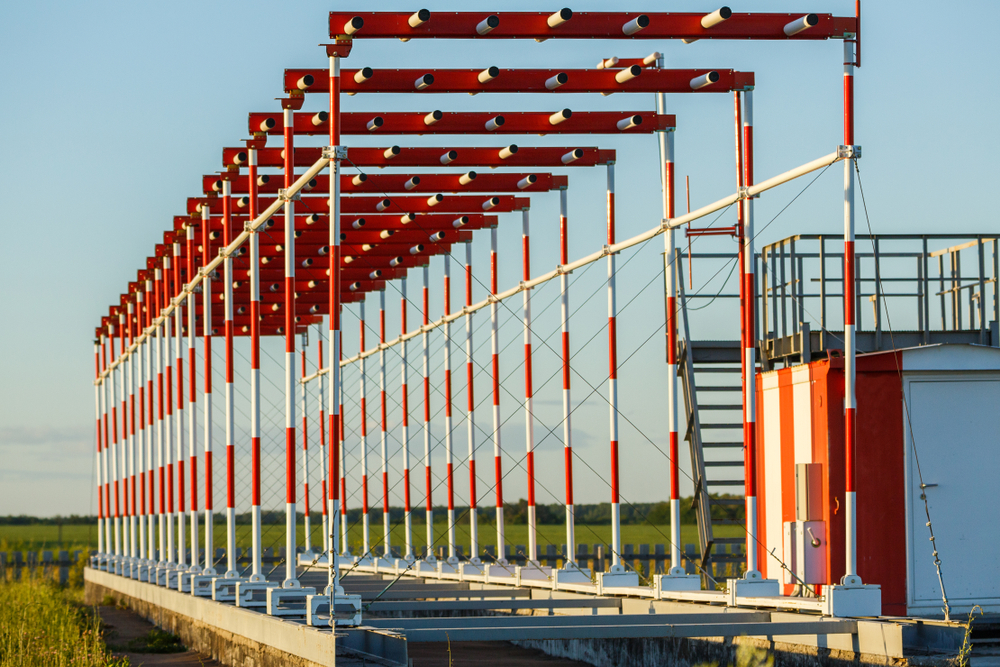
The image below is of the ILS localiser. These are situated at the end of the runway for which it is providing guidance for.
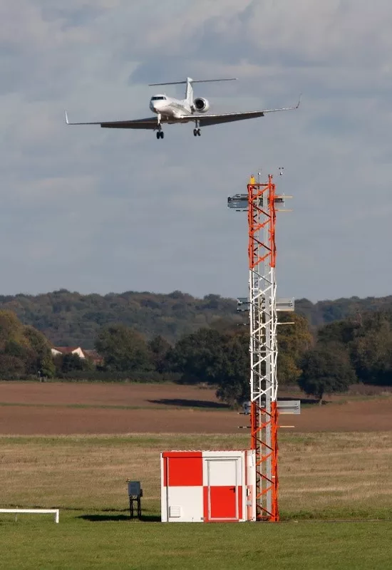
The image below is of the ILS glide slope antenna. These are situated abeam the touchdown zone for the runway.


